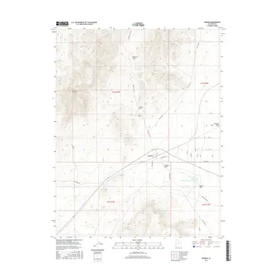
2017 Map of Modena
USGS Topo · Published 2017About this map
Modena serves as the focal point of this Iron County landscape, positioned where the high desert meets the base of notable peaks. To the north, the terrain rises toward Mt Elenore and the winding Elderberry Canyon, while the southern expanse transitions into the Escalante Desert. This 2017 survey details a network of vital water management and drainage features, including the Modena Draw Reservoir and numerous desert washes such as Gold Springs Wash and Hogans Wash. Local history is anchored by the Modena Cem and a grid of rural roads like Hamlin Valley Rd and Old Modena Rd that connect the small settlement to its surroundings. The map provides a clear view of how modern transportation corridors, including Modena Main St and W Center St, integrate with the natural drainage patterns of Modena Draw and McDonald Wash.
Find a feature on this map
24 named features on this map. Tap any name to fly to it.
Don’t see what you’re looking for? This feature index may not catch every label — zoom into the map to look around manually.
Map Details
Editions of this 2017 Modena Map
This is the sole edition of this map. No revisions or reprints were ever made.
Other maps of this area

1885 · St. George
USGS Topo · 1:250,000

1885 · Pioche
USGS Topo · 1:250,000

1886 · Pioche
USGS Topo · 1:250,000

1891 · St. George
USGS Topo · 1:250,000

1953 · Cedar City
USGS Topo · 1:250,000

1954 · Caliente
USGS Topo · 1:250,000

1958 · Cedar City
USGS Topo · 1:250,000

1959 · Caliente
USGS Topo · 1:250,000

1962 · Cedar City
USGS Topo · 1:250,000
1972 · Uvada
USGS Topo · 1:24,000