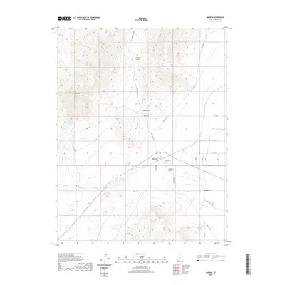
2020 Map of Modena
USGS Topo · Published 2020About this map
Modena sits at the edge of the Escalante Desert in this 2020 survey of Iron County. The landscape is defined by its arid drainage systems and high peaks, notably Mt Elenore to the west and the carved depths of Elderberry Canyon to the north. Water sources, vital in this desert environment, are documented at Desert Spring and along seasonal courses such as Gold Springs Wash, Hogans Wash, and McDonald Wash. The settlement pattern is sparse, centered on the intersection of W Center St and Modena Main St, with the Modena Cem nearby serving as a primary point of interest for genealogists. The road network, including Hamblin Valley Rd and Old Modena Rd, illustrates the connectivity of this high-desert region, while the Modena Draw provides a clear view of the natural topography that has influenced local transit and land use for decades.
Find a feature on this map
19 named features on this map. Tap any name to fly to it.
Don’t see what you’re looking for? This feature index may not catch every label — zoom into the map to look around manually.
Map Details
Editions of this 2020 Modena Map
This is the sole edition of this map. No revisions or reprints were ever made.
Other maps of this area

1885 · St. George
USGS Topo · 1:250,000

1885 · Pioche
USGS Topo · 1:250,000

1886 · Pioche
USGS Topo · 1:250,000

1891 · St. George
USGS Topo · 1:250,000

1953 · Cedar City
USGS Topo · 1:250,000

1954 · Caliente
USGS Topo · 1:250,000

1958 · Cedar City
USGS Topo · 1:250,000

1959 · Caliente
USGS Topo · 1:250,000

1962 · Cedar City
USGS Topo · 1:250,000
1972 · Uvada
USGS Topo · 1:24,000