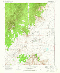
1972 Map of Modena
USGS Topo · Published 1976About this map
Modena serves as the focal point of this southwestern Utah landscape, situated at a junction of rail and desert transport routes. The Union Pacific railroad cuts a diagonal line across the high desert, supported by localized infrastructure including Landing Strips, a Water Tank, and the Modena Cem. The presence of an Old Railroad Grade to the east indicates an earlier alignment or a defunct spur, illustrating the evolution of the region's transportation network.
Find a feature on this map
18 named features on this map. Tap any name to fly to it.
Don’t see what you’re looking for? This feature index may not catch every label — zoom into the map to look around manually.
Map Details
Editions of this 1972 Modena Map
This is the sole edition of this map. No revisions or reprints were ever made.
Other maps of this area

1885 · St. George
USGS Topo · 1:250,000

1885 · Pioche
USGS Topo · 1:250,000

1886 · Pioche
USGS Topo · 1:250,000

1891 · St. George
USGS Topo · 1:250,000

1953 · Cedar City
USGS Topo · 1:250,000

1954 · Caliente
USGS Topo · 1:250,000

1958 · Cedar City
USGS Topo · 1:250,000

1959 · Caliente
USGS Topo · 1:250,000

1962 · Cedar City
USGS Topo · 1:250,000
1972 · Uvada
USGS Topo · 1:24,000