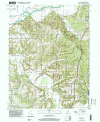
1998 Map of Modesto
USGS Topo · Published 2002About this map
White River and its floodplain dominate the northern reaches of this landscape, where the Paragon Bridge crosses the water near the border of Ray and Baker townships. The central and eastern portions of the map are defined by the dense, hilly terrain of the Morgan-Monroe State Forest, a large tract of preserved land that straddles the Morgan-Monroe county line. This area remains largely undeveloped, characterized by numerous drainages like Bear Hollow and Indian Creek.
Find a feature on this map
47 named features on this map. Tap any name to fly to it.
Don’t see what you’re looking for? This feature index may not catch every label — zoom into the map to look around manually.
Map Details
Editions of this 1998 Modesto Map
This is the sole edition of this map. No revisions or reprints were ever made.
Other maps of this area

1908 · Bloomington
USGS Topo · 1:48,000

1910 · Bloomington
USGS Topo · 1:62,500

1942 · Franklin
USGS Topo · 1:125,000

1947 · Unionville
USGS Topo · 1:24,000

1947 · Gosport
USGS Topo · 1:24,000

1948 · Hindustan
USGS Topo · 1:24,000

1949 · Quincy
USGS Topo · 1:24,000

1950 · Gosport
USGS Topo · 1:24,000

1953 · Indianapolis
USGS Topo · 1:250,000

1955 · Martinsville
USGS Topo · 1:24,000