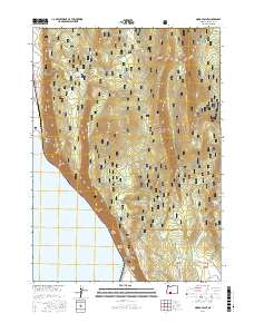
2017 Map of Modoc Point
USGS Topo · Published 2017About this map
Modoc Point rises sharply above the eastern shore of Upper Klamath Lake, marking a dramatic transition between the water and the elevated terrain of the Winema National Forest. This 2017 survey shows a landscape defined by volcanic geology and vital water sources, with several named springs such as Ouxy Spring, Sucker Spring, and Barkley Spring emerging at the base of the ridges. To the north, Telephone Flat and Chiloquin Ridge dominate the interior, while the eastern edge of the map gives way to the open spaces of Antelope Valley. The placement of Hagelstein and County Highway 671 along the narrow strip of land between the cliffs and the lake highlights the importance of this corridor for travel. Notable for its diverse terrain names, the map also includes the distinctive Hell for Slim Draw and the high-elevation Wrights Meadows near the northern boundary.
Find a feature on this map
26 named features on this map. Tap any name to fly to it.
Don’t see what you’re looking for? This feature index may not catch every label — zoom into the map to look around manually.
Map Details
Editions of this 2017 Modoc Point Map
This is the sole edition of this map. No revisions or reprints were ever made.
Other maps of this area

1889 · Klamath
USGS Topo · 1:250,000

1894 · Klamath
USGS Topo · 1:250,000

1955 · Klamath Falls
USGS Topo · 1:250,000

1956 · Calimus Butte
USGS Topo · 1:62,500

1957 · Chiloquin
USGS Topo · 1:62,500

1957 · Swan Lake
USGS Topo · 1:62,500

1957 · Modoc Point
USGS Topo · 1:62,500

1958 · Klamath Falls
USGS Topo · 1:250,000

1980 · Williamson River
USGS Topo · 1:100,000
1985 · Shoalwater Bay
USGS Topo · 1:24,000