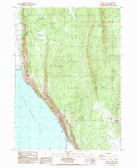
1985 Map of Modoc Point
USGS Topo · Published 1985About this map
The dramatic Modoc Rim defines the eastern shoreline of Upper Klamath Lake, creating a sharp topographical boundary between the water and the elevated lands of the Winema National Forest. This 1985 survey illustrates the transportation corridor squeezed between the cliffs and the water, where the Southern Pacific railroad and roads like the Hageldstein Park Rd & RR on Levee track the lake's edge. This narrow strip of land is punctuated by vital freshwater sources such as Sucker Spring and Barkley Spring, which historically served as critical points for travelers and residents alike. Further inland, the map transitions into the timbered slopes of Anderson Ridge and the grazing lands of Antelope Valley, where small-scale industrial activity is evidenced by a Borrow Pit and Cinder Pit. This map preserves the mid-1980s layout of the Indian Reservation Boundary and secluded locations like Telephone Flat.
Find a feature on this map
27 named features on this map. Tap any name to fly to it.
Don’t see what you’re looking for? This feature index may not catch every label — zoom into the map to look around manually.
Map Details
Editions of this 1985 Modoc Point Map
This is the sole edition of this map. No revisions or reprints were ever made.
Other maps of this area

1889 · Klamath
USGS Topo · 1:250,000

1894 · Klamath
USGS Topo · 1:250,000

1955 · Klamath Falls
USGS Topo · 1:250,000

1956 · Calimus Butte
USGS Topo · 1:62,500

1957 · Chiloquin
USGS Topo · 1:62,500

1957 · Swan Lake
USGS Topo · 1:62,500

1957 · Modoc Point
USGS Topo · 1:62,500

1958 · Klamath Falls
USGS Topo · 1:250,000

1980 · Williamson River
USGS Topo · 1:100,000
1985 · Shoalwater Bay
USGS Topo · 1:24,000