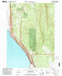
1998 Map of Modoc Point
USGS Topo · Published 2000About this map
Upper Klamath Lake dominates the western shoreline of this Klamath County region, where the sheer rise of the Modoc Rim creates a dramatic vertical landscape. The settlement of Modoc Point sits at the base of these cliffs, serving as a landmark along the water's edge. Much of the terrain to the east is defined by the Winema National Forest, a high-elevation plateau marked by timbered ridges and volcanic features like the Chiloquin Ridge.
Find a feature on this map
23 named features on this map. Tap any name to fly to it.
Don’t see what you’re looking for? This feature index may not catch every label — zoom into the map to look around manually.
Map Details
Editions of this 1998 Modoc Point Map
This is the sole edition of this map. No revisions or reprints were ever made.
Other maps of this area

1889 · Klamath
USGS Topo · 1:250,000

1894 · Klamath
USGS Topo · 1:250,000

1955 · Klamath Falls
USGS Topo · 1:250,000

1956 · Calimus Butte
USGS Topo · 1:62,500

1957 · Chiloquin
USGS Topo · 1:62,500

1957 · Swan Lake
USGS Topo · 1:62,500

1957 · Modoc Point
USGS Topo · 1:62,500

1958 · Klamath Falls
USGS Topo · 1:250,000

1980 · Williamson River
USGS Topo · 1:100,000
1985 · Shoalwater Bay
USGS Topo · 1:24,000