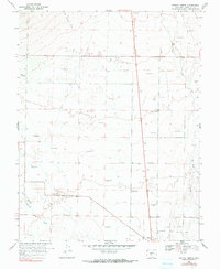
1968 Map of Moffat North
USGS Topo · Published 1990About this map
The settlement of Moffat sits at the southern edge of this San Luis Valley landscape, surveyed in the late 1960s. The terrain is defined by a complex network of flowing wells and seasonal drainages, including the San Luis Creek and the North Branch Saguache Creek. This area illustrates the critical role of groundwater in Colorado's high-altitude basins, with numerous wells scattered across the valley floor to support the region's agricultural and ranching efforts. In the northern reaches, the small community of Mirage appears alongside an Old Railroad Grade, marking the legacy of transportation routes that once traversed the flats. Notable geographic markers like Big Hollow Gulch and localized industry such as a Gravel Pit provide specific points of reference for those studying the physical development and land use of Saguache County.
Find a feature on this map
7 named features on this map. Tap any name to fly to it.
Don’t see what you’re looking for? This feature index may not catch every label — zoom into the map to look around manually.
Map Details
Editions of this 1968 Moffat North Map
2 editions found
Other maps of this area

1915 · Del Norte
USGS Topo · 1:125,000

1917 · Del Norte
USGS Topo · 1:125,000

1945 · Durango
USGS Topo · 1:250,000

1950 · Valley View Hot Springs
USGS Topo · 1:24,000

1953 · Durango
USGS Topo · 1:250,000

1954 · Durango
USGS Topo · 1:250,000

1954 · Trinidad
USGS Topo · 1:250,000

1954 · Pueblo
USGS Topo · 1:250,000

1955 · Trinidad
USGS Topo · 1:250,000

1956 · Montrose
USGS Topo · 1:250,000