
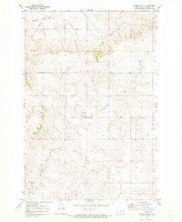
1971 Map of Moffit SW
USGS Topo · Published 1973About this map
The Old Fort Rice Military Reservation Boundary angles across this portion of Emmons County, marking a significant historical line of demarcation in the North Dakota landscape. This 1971 survey reveals a terrain defined by subtle watercourses and prominent rises, including the distinct Rattlesnake Butte which stands as a landmark above the surrounding plains. The drainage patterns of Badger Creek and the steep contours of Devils Gulch characterize the local geography, while the broad Buchanan Valley occupies the eastern portion of the sheet. The map serves as a precise record of rural land divisions and section lines just south of the state capital region during the early 1970s, capturing the area before modern agricultural or infrastructure changes altered the surface features and old military boundaries.
Find a feature on this map
7 named features on this map. Tap any name to fly to it.
Don’t see what you’re looking for? This feature index may not catch every label — zoom into the map to look around manually.
Map Details
Editions of this 1971 Moffit SW Map
This is the sole edition of this map. No revisions or reprints were ever made.
Other maps of this area

1907 · Bismarck
USGS Topo · 1:125,000

1954 · Bismarck
USGS Topo · 1:250,000

1958 · Bismarck
USGS Topo · 1:250,000

1968 · Cannon Ball
USGS Topo · 1:24,000

1971 · Hazelton
USGS Topo · 1:24,000

1971 · Moffit SE
USGS Topo · 1:24,000

1971 · Fort Rice
USGS Topo · 1:24,000

1971 · Huff NE
USGS Topo · 1:24,000

1971 · Moffit NW
USGS Topo · 1:24,000
1971 · Hazelton NW
USGS Topo · 1:24,000