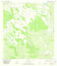
1980 Map of Mogotes Hill
USGS Topo · Published 1980About this map
Mogotes Hill rises as a prominent landmark in this Zapata County landscape, which by 1980 was heavily defined by the regional energy industry. A network of Gas Wells and an extensive Pipeline cross the terrain, supported by infrastructure like a Pumping Station and multiple storage Tanks. The natural drainage of the South Texas brush country is clearly mapped through winding ephemeral watercourses including Arroyo Blanco, Salomoneño Creek, and Escobas Creek. Of particular interest to genealogists and local historians is a lone Grave marked near the center of the sheet, suggesting a small family burial or isolated memorial away from established towns. The mapping also details smaller drainages such as Cañada Honda and Taguache Creek, illustrating the complex hydrology of this arid region prior to modern development.
Find a feature on this map
13 named features on this map. Tap any name to fly to it.
Don’t see what you’re looking for? This feature index may not catch every label — zoom into the map to look around manually.
Map Details
Editions of this 1980 Mogotes Hill Map
This is the sole edition of this map. No revisions or reprints were ever made.
Other maps of this area

1940 · Mogotes Hill
USGS Topo · 1:62,500

1942 · San Ygnacio
USGS Topo · 1:62,500

1949 · Mc Allen
USGS Topo · 1:250,000

1954 · McAllen
USGS Topo · 1:250,000

1956 · Mogotes Hill
USGS Topo · 1:62,500

1956 · Zapata
USGS Topo · 1:62,500

1956 · Arroyo Clareno
USGS Topo · 1:62,500

1956 · Laredo
USGS Topo · 1:250,000

1957 · Mc Allen
USGS Topo · 1:250,000

1962 · McAllen
USGS Topo · 1:250,000