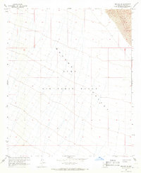
1965 Map of Mohawk SE
USGS Topo · Published 1966About this map
Mohawk Valley dominates this 1965 survey, a landscape defined by an extensive drainage system of ephemeral washes flowing through the arid Southwest. This specific area is designated as the Luke Air Force Range, highlighting the mid-century military utilization of the Yuma County desert. In the northeast corner, the topography shifts abruptly into a field of Sand Dunes, where the terrain elevation rises sharply. The map captures a moment when the U.S. Bureau of Reclamation was active in the region, with data integrated from earlier 1940s planetable surveys. The lack of permanent structures or roads across this vast stretch reflects the area's specialized role as a military proving ground and restricted wilderness during the Cold War era.
Find a feature on this map
7 named features on this map. Tap any name to fly to it.
Don’t see what you’re looking for? This feature index may not catch every label — zoom into the map to look around manually.
Map Details
Editions of this 1965 Mohawk SE Map
2 editions found
Other maps of this area

1926 · Mohawk
USGS Topo · 1:62,500

1927 · Kim
USGS Topo · 1:62,500

1928 · Mohawk
USGS Topo · 1:62,500

1931 · Kim
USGS Topo · 1:62,500

1953 · Ajo
USGS Topo · 1:250,000

1957 · Ajo
USGS Topo · 1:250,000

1958 · Ajo
USGS Topo · 1:250,000

1962 · Ajo
USGS Topo · 1:250,000

1963 · Ajo
USGS Topo · 1:250,000

1965 · Cabeza Prieta Peak
USGS Topo · 1:62,500