
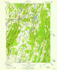
1942 Map of Mohonk Lake
USGS Topo · Published 1959About this map
Rondout Creek meanders through this section of the Hudson Valley, following a path flanked by the New York Ontario And Western railroad. The landscape reveals a dense network of mid-century rural infrastructure, from the Accord Airport to numerous local schoolhouses such as Rock Hill Sch and Oak Grove Sch. Along the river's edge, an Abandoned Canal segment parallels the water near Alligerville, reflecting the transition from nineteenth-century water transport to the rail era represented by Kyserike Sta. To the southeast, the terrain rises sharply into the Shawangunk Mountain range, where Mohonk Lake and Eagle Cliff provide a dramatic contrast to the agricultural flats of Rochester and Marbletown. Small hamlets like St Josen, Kripplebush, and Lyonsville anchor the surrounding woods and fields.
Find a feature on this map
48 named features on this map. Tap any name to fly to it.
Don’t see what you’re looking for? This feature index may not catch every label — zoom into the map to look around manually.
Map Details
Editions of this 1942 Mohonk Lake Map
This is the sole edition of this map. No revisions or reprints were ever made.
Other maps of this area

1901 · Rosendale
USGS Topo · 1:62,500

1903 · Newburg
USGS Topo · 1:62,500

1903 · Rosendale
USGS Topo · 1:62,500

1903 · Slide Mountain
USGS Topo · 1:62,500

1904 · Ellenville
USGS Topo · 1:62,500

1905 · Slide Mountain
USGS Topo · 1:62,500

1906 · Ellenville
USGS Topo · 1:62,500

1942 · Kingston West
USGS Topo · 1:24,000
1942 · Rosendale
USGS Topo · 1:24,000
1942 · West Shokan
USGS Topo · 1:24,000