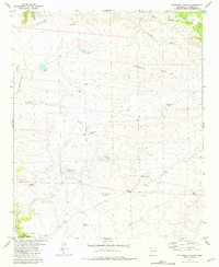
1981 Map of Mojonera Canyon
USGS Topo · Published 1981About this map
The Continental Divide winds through this high-altitude landscape in Catron County, dictating the flow of water across a network of seasonal tanks and livestock-supporting windmills. Mapping in the late 1960s and mid-1970s reveals a terrain defined by ranching infrastructure and remote landmarks, most notably a solitary Grave situated near Mojonera Canyon. This marker of human history stands in stark contrast to the surrounding wilderness, where named water sources like Henry Ford Tank and Rock House Tank illustrate the necessity of water management for survival in the New Mexico high country. In the southern portion of the map, the Gila National Forest boundary encompasses Railroad Canyon and Buffalo Tank, while the northern reaches feature the expanse of Laguna Hondo. This survey provides a precise record of the land use patterns and isolated improvements that characterized this portion of the American West during the late twentieth century.
Find a feature on this map
18 named features on this map. Tap any name to fly to it.
Don’t see what you’re looking for? This feature index may not catch every label — zoom into the map to look around manually.
Map Details
Editions of this 1981 Mojonera Canyon Map
This is the sole edition of this map. No revisions or reprints were ever made.
Other maps of this area

1918 · Pelona
USGS Topo · 1:125,000

1954 · Tularosa
USGS Topo · 1:250,000

1954 · Clifton
USGS Topo · 1:250,000

1957 · Clifton
USGS Topo · 1:250,000

1958 · Clifton
USGS Topo · 1:250,000

1958 · Tularosa
USGS Topo · 1:250,000

1962 · Clifton
USGS Topo · 1:250,000

1965 · Wahoo Peak
USGS Topo · 1:24,000

1979 · San Mateo Mountains
USGS Topo · 1:100,000
1981 · Pelona Mountain
USGS Topo · 1:24,000