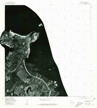
1978 Map of Mokapu
USGS Topo · Published 1981About this map
Kawainui Swamp anchors the landscape in this orthophotoquad, which utilizes aerial imagery taken in late 1976 and early 1978 to document the windward coast of Oahu. Unlike a traditional line-and-symbol map, this photographic representation shows the actual texture of the residential development, coastal military infrastructure, and natural marshlands as they existed in the late seventies. The visual contrast between the dense residential street grids and the sprawling, undeveloped expanse of the wetland provides a clear record of land use and suburban growth on the Mokapu peninsula. Produced by the Geological Survey in cooperation with the State of Hawaii, the imagery captures the fine-grain details of docks, airfields, and the rugged shoreline that topographic contours alone often obscure.
Find a feature on this map
1 named feature on this map. Tap any name to fly to it.
Don’t see what you’re looking for? This feature index may not catch every label — zoom into the map to look around manually.
Map Details
Editions of this 1978 Mokapu Map
This is the sole edition of this map. No revisions or reprints were ever made.
Other maps of this area

1952 · Koko Head
USGS Topo · 1:24,000

1952 · Mokapu
USGS Topo · 1:24,000

1953 · Honolulu
USGS Topo · 1:24,000

1954 · Oahu
USGS Topo · 1:250,000

1954 · Kahana
USGS Topo · 1:24,000

1954 · Kaneohe
USGS Topo · 1:24,000

1959 · Mokapu
USGS Topo · 1:24,000

1959 · Koko Head
USGS Topo · 1:24,000

1959 · Kaneohe
USGS Topo · 1:24,000

1959 · Honolulu
USGS Topo · 1:24,000