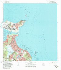
1983 Map of Mokapu
USGS Topo · Published 1983About this map
Kaneohe Bay Marine Corps Air Station dominates the northern peninsula of this 1983 survey, situated between the waters of Kaneohe Bay and the open Pacific Ocean. The map documents the residential landscape of Windward Oahu in the early 1980s, showcasing the suburban expansion in Kailua and Lanikai adjacent to the prominent Ulupau Crater. Significant ecological and cultural sites are noted, including the Kawainui Swamp and the ancient Ulupo Heiau near the settlement of Pohakupu. Along the coastline, several offshore refuges like Moku Manu and the Mokulua Islands are identified, while inland development is marked by Enchanted Lake and the Mid Pacific Country Club. This edition reflects the dual nature of the region as both a critical military hub, including Bellows Air Force Station, and a rapidly maturing residential and recreational community.
Find a feature on this map
60 named features on this map. Tap any name to fly to it.
Don’t see what you’re looking for? This feature index may not catch every label — zoom into the map to look around manually.
Map Details
Editions of this 1983 Mokapu Map
This is the sole edition of this map. No revisions or reprints were ever made.
Other maps of this area

1952 · Koko Head
USGS Topo · 1:24,000

1952 · Mokapu
USGS Topo · 1:24,000

1953 · Honolulu
USGS Topo · 1:24,000

1954 · Oahu
USGS Topo · 1:250,000

1954 · Kahana
USGS Topo · 1:24,000

1954 · Kaneohe
USGS Topo · 1:24,000

1959 · Mokapu
USGS Topo · 1:24,000

1959 · Koko Head
USGS Topo · 1:24,000

1959 · Kaneohe
USGS Topo · 1:24,000

1959 · Honolulu
USGS Topo · 1:24,000