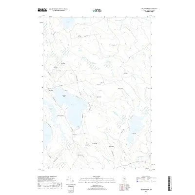
2018 Map of Molasses Pond
USGS Topo · Published 2018About this map
Molasses Pond and the surrounding Hancock County wilderness are defined by a complex network of glacial ponds, brooks, and heaths in this 2018 survey. The landscape is characterized by prominent elevations such as Bull Hill and Sugar Hill which rise above extensive wetlands like Sams Heath and Austins Dam Heath. Local history and genealogy are anchored at the Crimmins Cem near Neck Ridge, while the settlement at Chez Vent sits on the western shore of Narraguagus Lake. The drainage patterns are clearly visible through the Bog River and Macomber Mill Stream, reflecting a terrain where water dictates the location of early industry and modern recreation. Access is maintained through a web of local routes including Macomber Mill Rd and Stone Dam Rd, connecting isolated pockets of settlement within the dense Maine woods.
Find a feature on this map
63 named features on this map. Tap any name to fly to it.
Don’t see what you’re looking for? This feature index may not catch every label — zoom into the map to look around manually.
Map Details
Editions of this 2018 Molasses Pond Map
This is the sole edition of this map. No revisions or reprints were ever made.
Other maps of this area

1911 · Ellsworth
USGS Topo · 1:62,500

1929 · Great Pond
USGS Topo · 1:48,000

1929 · Lead Mountain
USGS Topo · 1:48,000

1930 · Tunk Lake
USGS Topo · 1:48,000

1932 · Tunk Lake
USGS Topo · 1:62,500

1932 · Lead Mountain
USGS Topo · 1:62,500

1932 · Great Pond
USGS Topo · 1:62,500

1940 · Ellsworth
USGS Topo · 1:62,500

1942 · Ellsworth
USGS Topo · 1:62,500

1942 · Tunk Lake
USGS Topo · 1:62,500