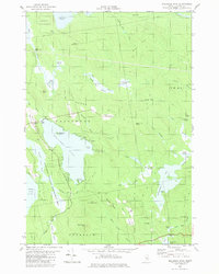
1982 Map of Molasses Pond
USGS Topo · Published 1983About this map
Molasses Pond and the surrounding wetlands of Hancock County define this landscape as it appeared in the early 1980s. The area is a complex network of heaths and water bodies, including Sams Heath and Austins Dam Heath, illustrating the glacial hydrology of the Maine interior. Much of the western shore is protected within the Lyle Frost Wildlife Management Area, which encompasses Scammon Pond and Lyle Frost Pond.
Find a feature on this map
54 named features on this map. Tap any name to fly to it.
Don’t see what you’re looking for? This feature index may not catch every label — zoom into the map to look around manually.
Map Details
Editions of this 1982 Molasses Pond Map
This is the sole edition of this map. No revisions or reprints were ever made.
Other maps of this area

1911 · Ellsworth
USGS Topo · 1:62,500

1929 · Great Pond
USGS Topo · 1:48,000

1929 · Lead Mountain
USGS Topo · 1:48,000

1930 · Tunk Lake
USGS Topo · 1:48,000

1932 · Tunk Lake
USGS Topo · 1:62,500

1932 · Lead Mountain
USGS Topo · 1:62,500

1932 · Great Pond
USGS Topo · 1:62,500

1940 · Ellsworth
USGS Topo · 1:62,500

1942 · Ellsworth
USGS Topo · 1:62,500

1942 · Tunk Lake
USGS Topo · 1:62,500