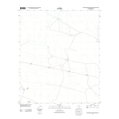
2012 Map of Molesworth Mesa North
USGS Topo · Published 2012About this map
Cornudas Ranch and Double U Ranch anchor this arid Hudspeth County landscape, reflecting the sparse ranching infrastructure typical of West Texas in the early 21st century. The terrain is defined by the high ground of Molesworth Mesa in the south, giving way to the erosional patterns of Buck Horn Draw. A network of unpaved tracks, including Stewart Ranch Rd, connects remote outposts and vital water sources such as Snake Tank, Brown Tank, and the aptly named The Lake. This map captures a landscape where survival depends on these scattered catchments, providing a detailed look at the ranching economy and geographical layout of the High Desert before more recent developments changed the region's character.
Find a feature on this map
12 named features on this map. Tap any name to fly to it.
Don’t see what you’re looking for? This feature index may not catch every label — zoom into the map to look around manually.
Map Details
Editions of this 2012 Molesworth Mesa North Map
This is the sole edition of this map. No revisions or reprints were ever made.
Other maps of this area

1903 · Cerro Alto
USGS Topo · 1:125,000

1943 · Tepee Butte
USGS Topo · 1:62,500

1943 · San Antonio Mtn
USGS Topo · 1:62,500

1951 · Red Hills
USGS Topo · 1:62,500

1954 · Van Horn
USGS Topo · 1:250,000

1955 · Cerro Diablo
USGS Topo · 1:62,500

1958 · Van Horn
USGS Topo · 1:250,000
1978 · Molesworth Mesa South
USGS Topo · 1:24,000
1978 · Tepee Butte
USGS Topo · 1:24,000
1979 · Buckhorn Draw East
USGS Topo · 1:24,000