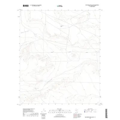
2019 Map of Molesworth Mesa South
USGS Topo · Published 2019About this map
Molesworth Mesa dominates this West Texas landscape in Hudspeth County, illustrating the arid drainage patterns of the Trans-Pecos region. The terrain is defined by significant natural depressions and water catchments, including the Number Nine Draw and the long course of Antelope Draw. Because water is the primary limiting factor for land use in this high-desert environment, the map specifically identifies vital catchment features like Drag Tank, Hobo Tank, and the Antelope Tanks. These small, localized water sources often dictated the movement of livestock and people in a region otherwise characterized by vast stretches of open land and sparse infrastructure. The single prominent arterial route, Pipeline Rd, cuts across the high ground, reflecting the industrial utility that connects these isolated ranchlands to wider energy networks.
Find a feature on this map
7 named features on this map. Tap any name to fly to it.
Don’t see what you’re looking for? This feature index may not catch every label — zoom into the map to look around manually.
Map Details
Editions of this 2019 Molesworth Mesa South Map
This is the sole edition of this map. No revisions or reprints were ever made.
Other maps of this area

1903 · Cerro Alto
USGS Topo · 1:125,000

1943 · Tepee Butte
USGS Topo · 1:62,500

1943 · San Antonio Mtn
USGS Topo · 1:62,500

1951 · Red Hills
USGS Topo · 1:62,500

1954 · Van Horn
USGS Topo · 1:250,000

1955 · Cerro Diablo
USGS Topo · 1:62,500

1958 · Van Horn
USGS Topo · 1:250,000
1978 · Granite Mountain
USGS Topo · 1:24,000
1978 · Molesworth Mesa South
USGS Topo · 1:24,000
1978 · Tepee Butte SW
USGS Topo · 1:24,000