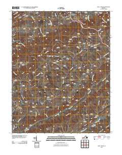
2010 Map of Moll Creek
USGS Topo · Published 2010About this map
Banners Corner and Mew serve as quiet anchors for this landscape in Russell County, which is defined by an extraordinarily dense concentration of family burial grounds and small mountain settlements. Genealogists will find a wealth of data points here, as the terrain is peppered with dozens of named sites such as Fraley Cemetery, Saddler Cemetery, and Culbertson Cemetery. The map reveals a specialized local geography where nearly every ridge and hollow bears a family name, including Osborne Hollow and Minton Hollow. Drainage patterns follow the deep folds of the land, with Copper Creek and Big Moccasin Creek cutting through the southern valleys, while Little Copper Creek and Meade Creek navigate the central ridges. The presence of tiny locales like Point Truth and Lawsons Store suggests a community structure built around narrow mountain passes and crossroads, preserved here in the first decade of the 21st century.
Find a feature on this map
93 named features on this map. Tap any name to fly to it.
Don’t see what you’re looking for? This feature index may not catch every label — zoom into the map to look around manually.
Map Details
Editions of this 2010 Moll Creek Map
This is the sole edition of this map. No revisions or reprints were ever made.
Other maps of this area

1897 · Bristol
USGS Topo · 1:125,000

1902 · Bristol
USGS Topo · 1:125,000

1918 · Carterton
USGS Topo · 1:62,500

1920 · Coeburn
USGS Topo · 1:48,000

1934 · Wallace
USGS Topo · 1:24,000

1934 · Hansonville
USGS Topo · 1:24,000
1934 · Carbo
USGS Topo · 1:24,000

1935 · Hilton
USGS Topo · 1:24,000

1935 · Mendota
USGS Topo · 1:24,000
1935 · Moll Creek
USGS Topo · 1:24,000