
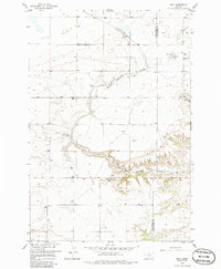
1956 Map of Molt
USGS Topo · Published 1957About this map
Molt serves as the primary rail-side hub for this section of the Montana landscape, situated along the Northern Pacific line where it snakes through the upper drainage of Canyon Creek. The topography is defined by the sharp transition from the level reaches of the Basin in the northwest to the deeply incised draws and canyons that drop toward the southeast. For local history researchers, the map provides specific placements for the Lazy K T Ranch and the Luckey Homestead, offering a look at rural land tenure in the mid-1950s. Water management is a central theme, evidenced by numerous Spring and Well points, alongside Indian Spring and the Morgan Spring. The Stillwater Co Yellowstone Co line bisects the eastern portion of the sheet, cutting across the rugged breaks and the high, level plateau of the Flat.
Find a feature on this map
18 named features on this map. Tap any name to fly to it.
Don’t see what you’re looking for? This feature index may not catch every label — zoom into the map to look around manually.
Map Details
Editions of this 1956 Molt Map
2 editions found
Other maps of this area

1892 · Stillwater
USGS Topo · 1:125,000

1954 · Billings
USGS Topo · 1:250,000

1956 · Comanche
USGS Topo · 1:24,000

1956 · Hunter Lake
USGS Topo · 1:24,000

1956 · Horse Butte
USGS Topo · 1:24,000

1956 · Wheat Basin
USGS Topo · 1:24,000

1956 · Rock Spring
USGS Topo · 1:24,000

1956 · Two Pine School
USGS Topo · 1:24,000

1956 · Laurel
USGS Topo · 1:24,000

1956 · Park City
USGS Topo · 1:24,000