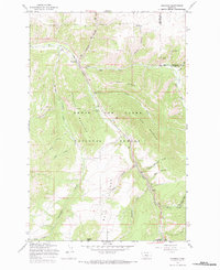
1967 Map of Monarch
USGS Topo · Published 1983About this map
Monarch stands at the confluence of Belt Creek and Monarch Creek, serving as a central point in this mountain landscape within the Lewis and Clark National Forest. The map traces the Old Railroad Grade as it winds through the canyon alongside the creek, reflecting the region's historical dependence on rail transport for mountain access and industry. The presence of a Prospect and a Quarry near the canyon floor suggests the extraction activities that often shaped these high-country settlements.
Find a feature on this map
36 named features on this map. Tap any name to fly to it.
Don’t see what you’re looking for? This feature index may not catch every label — zoom into the map to look around manually.
Map Details
Editions of this 1967 Monarch Map
2 editions found
Other maps of this area

1886 · Little Belt Mts.
USGS Topo · 1:250,000

1890 · Fort Benton
USGS Topo · 1:250,000

1892 · Fort Benton
USGS Topo · 1:250,000

1894 · Little Belt Mts.
USGS Topo · 1:250,000

1897 · Fort Benton
USGS Topo · 1:250,000

1897 · Little Belt Mts.
USGS Topo · 1:250,000

1898 · Little Belt Mts.
USGS Topo · 1:250,000

1902 · Little Belt Mts.
USGS Topo · 1:250,000

1948 · White Sulphur Springs
USGS Topo · 1:250,000

1954 · Great Falls
USGS Topo · 1:250,000