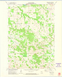
1973 Map of Mondovi NE
USGS Topo · Published 1975About this map
The township of Brunswick and the surrounding Eau Claire County countryside are defined by a network of rural crossroads and family landmarks in the early 1970s. This survey records the distinct spatial organization of local life, where small congregations at Apostolic Faith Ch, Drammen Ch, and Pleasant Valley Ch served as anchors for the farming community. The landscape is carved by numerous watercourses, including West Creek, Coon Creek, and Rock Creek, which dictate the winding paths of rural roads named for the native timber, such as Cedar Road and Hemlock Road. Small-scale industrial activity is evident at several Quarry sites and a Gravel Pit near Cooley Lake. This map is particularly valuable for genealogists tracing ancestors in the Drammen and Washington areas, as it preserves the locations of local landmarks like Anthony Sch and the Township Cem before modern developments altered these traditional rural townships.
Find a feature on this map
32 named features on this map. Tap any name to fly to it.
Don’t see what you’re looking for? This feature index may not catch every label — zoom into the map to look around manually.
Map Details
Editions of this 1973 Mondovi NE Map
This is the sole edition of this map. No revisions or reprints were ever made.
Other maps of this area

1927 · Strum
USGS Topo · 1:62,500

1930 · Strum
USGS Topo · 1:62,500

1932 · Mondovi
USGS Topo · 1:62,500

1934 · Elk Mound
USGS Topo · 1:62,500

1934 · Chippewa Falls
USGS Topo · 1:62,500

1936 · Chippewa Falls
USGS Topo · 1:62,500

1936 · Elk Mound
USGS Topo · 1:62,500

1953 · Eau Claire
USGS Topo · 1:250,000

1958 · Eau Claire
USGS Topo · 1:250,000

1964 · Eau Claire
USGS Topo · 1:250,000