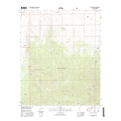
2017 Map of Monica Saddle
USGS Topo · Published 2017About this map
Cibola National Forest defines the rugged geography of this high-elevation region in Socorro County, where life and transit are governed by water sources and drainage patterns. The landscape is characterized by a series of prominent canyons, including Monica Canyon, Morine Canyon, and Durfee Canyon, which fall away from the divide at Monica Saddle. Strategic water points are essential markers for local history and forestry management, evidenced by named sites such as Monica Spring, Ranch Supply Spring, and Beartrap Spring. Historical transit corridors are visible via Old State Hwy 52, which winds along the eastern edge of the quadrangle. The map also records the network of timber and access routes like Forest Rd 220, providing a detailed look at the land use within this protected forest boundary.
Find a feature on this map
34 named features on this map. Tap any name to fly to it.
Don’t see what you’re looking for? This feature index may not catch every label — zoom into the map to look around manually.
Map Details
Editions of this 2017 Monica Saddle Map
This is the sole edition of this map. No revisions or reprints were ever made.
Other maps of this area

1954 · Tularosa
USGS Topo · 1:250,000

1954 · Socorro
USGS Topo · 1:250,000

1958 · Socorro
USGS Topo · 1:250,000

1958 · Tularosa
USGS Topo · 1:250,000

1962 · Socorro
USGS Topo · 1:250,000

1964 · Arrowhead Well
USGS Topo · 1:24,000

1964 · Bay Buck Peaks
USGS Topo · 1:24,000
1964 · Grassy Lookout
USGS Topo · 1:24,000

1964 · Monica Saddle
USGS Topo · 1:24,000

1964 · Tres Montosas
USGS Topo · 1:24,000