
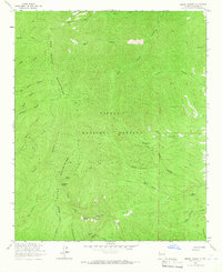
1964 Map of Monica Saddle
USGS Topo · Published 1966About this map
Cibola National Forest encompasses this high-elevation landscape in Socorro County, where steep drainages and isolated landmarks define the local geography. In the mid-1960s, the area was characterized by a network of seasonal water sources and deep ravines, such as Durfee Canyon and Bolander Canyon. The Durfee Ranch stands as a primary point of human settlement in the north, while the southern terrain is dominated by the namesake Monica Saddle and Point of Rocks Canyon.
Find a feature on this map
14 named features on this map. Tap any name to fly to it.
Don’t see what you’re looking for? This feature index may not catch every label — zoom into the map to look around manually.
Map Details
Editions of this 1964 Monica Saddle Map
This is the sole edition of this map. No revisions or reprints were ever made.
Other maps of this area

1954 · Tularosa
USGS Topo · 1:250,000

1954 · Socorro
USGS Topo · 1:250,000

1958 · Socorro
USGS Topo · 1:250,000

1958 · Tularosa
USGS Topo · 1:250,000

1962 · Socorro
USGS Topo · 1:250,000

1964 · Arrowhead Well
USGS Topo · 1:24,000

1964 · Bay Buck Peaks
USGS Topo · 1:24,000
1964 · Grassy Lookout
USGS Topo · 1:24,000

1964 · Tres Montosas
USGS Topo · 1:24,000

1965 · Oak Peak
USGS Topo · 1:24,000