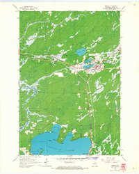
1965 Map of Monico
USGS Topo · Published 1967About this map
Monico stands at the junction of several rail lines and water bodies in this mid-1960s survey of Oneida County. The town is flanked by a series of planetary-named lakes, including Neptune Lake, Mars Lake, and Venus Lake, suggesting a unique local naming tradition. The Chicago and North Western railway cuts through the center of the township, which was a vital artery for the region's timber and recreational economy. Local religious life is anchored by Pentecost Ch near the town center and St Francis Chapel further south near the shoreline.
Find a feature on this map
33 named features on this map. Tap any name to fly to it.
Don’t see what you’re looking for? This feature index may not catch every label — zoom into the map to look around manually.
Map Details
Editions of this 1965 Monico Map
This is the sole edition of this map. No revisions or reprints were ever made.
Other maps of this area

1940 · Parrish
USGS Topo · 1:48,000

1940 · Monico
USGS Topo · 1:48,000

1940 · Rhinelander
USGS Topo · 1:48,000

1942 · Elcho
USGS Topo · 1:48,000

1949 · Rhinelander
USGS Topo · 1:48,000

1950 · Monico
USGS Topo · 1:48,000

1950 · Elcho
USGS Topo · 1:48,000

1950 · Parrish
USGS Topo · 1:48,000

1952 · Parrish
USGS Topo · 1:48,000

1954 · Iron Mountain
USGS Topo · 1:250,000