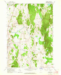
1963 Map of Monkton
USGS Topo · Published 1964About this map
The watershed of Little Otter Creek and Otter Creek shapes this portion of Addison County, where the transition from flat valley land to the heights of Hogback and Shellhouse Mountain defines the local geography. In the early 1960s, the landscape remained predominantly agricultural, marked by numerous small burial grounds such as Quaker Cem and Collins Cem that anchor the area's genealogical history. The map captures the civic layout of several interconnected townships, including the city of Vergennes with its Armory and Union High Sch, and the smaller village of Monkton. A distinct network of secondary roads, like Plank Road, links these settlements across a terrain punctuated by marshes, gravel pits, and the Vergennes Watershed forest. This survey provides a clear view of the rural Vermont infrastructure before modern expansion, preserving the locations of legacy institutions like Beeman Academy and the remote heights of Mt Fuller.
Find a feature on this map
42 named features on this map. Tap any name to fly to it.
Don’t see what you’re looking for? This feature index may not catch every label — zoom into the map to look around manually.
Map Details
Editions of this 1963 Monkton Map
3 editions found
Other maps of this area

1894 · Port Henry
USGS Topo · 1:62,500

1895 · Willsboro
USGS Topo · 1:62,500

1898 · Port Henry
USGS Topo · 1:62,500

1903 · Middlebury
USGS Topo · 1:62,500

1905 · Middlebury
USGS Topo · 1:62,500

1906 · Burlington
USGS Topo · 1:62,500

1919 · Burlington
USGS Topo · 1:62,500

1920 · Middlebury
USGS Topo · 1:62,500

1941 · Willsboro
USGS Topo · 1:62,500

1943 · Willsboro
USGS Topo · 1:62,500