1994 Map of Mono Mills
USGS Topo · Published 1997About this map
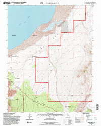
Mono Basin and the southern shoreline of Mono Lake define this high-altitude landscape during the mid-1990s. The map illustrates a region transitioning from its early industrial history toward conservation, bounded by the Mono National Forest and Inyo National Forest. At the heart of the terrain lies the site of Mono Mills, once a hub for lumber operations that served the distant silver mines.
Find a feature on this map
35 named features on this map. Tap any name to fly to it.
Don’t see what you’re looking for? This feature index may not catch every label — zoom into the map to look around manually.
Map Details
Editions of this 1994 Mono Mills Map
2 editions found

Other maps of this area

1901 · Mt. Lyell
USGS Topo · 1:125,000

1909 · Hawthorne
USGS Topo · 1:250,000

1909 · Bridgeport
USGS Topo · 1:125,000

1911 · Bridgeport
USGS Topo · 1:125,000

1911 · Hawthorne
USGS Topo · 1:250,000

1914 · Mt. Morrison
USGS Topo · 1:125,000

1915 · Hawthorne
USGS Topo · 1:250,000

1920 · Bridgeport
USGS Topo · 1:125,000

1947 · Mariposa
USGS Topo · 1:250,000

1948 · Walker Lake
USGS Topo · 1:250,000