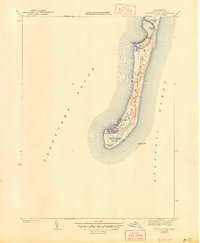
1942 Map of Monomoy Point
USGS Topo · Published 1947About this map
Monomoy Island appears as a slender, fragile landform stretching between Nantucket Sound and the Atlantic Ocean in this early 1940s survey. The landscape is defined by the shifting interface of sand and sea, with a simple trail threading the length of the spit to reach Monomoy Point. This coastal outpost is anchored by the Coast Guard Sta and the deep indentation of Powder Hole, which served as a natural harbor of refuge. The presence of the Monomoy Brant Club and Bristol Club reflects the area's legacy as a destination for maritime sportsmen and waterfowlers. Off the eastern shore, the Stone Horse Light Ship marks the treacherous shoals, highlighting the critical role of maritime safety in this corner of Barnstable County before modern automated aids. Other localized features like Hammonds Bend and Rump Hole provide a granular look at the island's unique hydrography.
Find a feature on this map
15 named features on this map. Tap any name to fly to it.
Don’t see what you’re looking for? This feature index may not catch every label — zoom into the map to look around manually.
Map Details
Editions of this 1942 Monomoy Point Map
2 editions found
Other maps of this area

1887 · Yarmouth
USGS Topo · 1:62,500

1888 · Chatham
USGS Topo · 1:62,500

1889 · Yarmouth
USGS Topo · 1:62,500

1893 · Chatham
USGS Topo · 1:62,500

1893 · Yarmouth
USGS Topo · 1:62,500

1917 · Chatham
USGS Topo · 1:62,500

1942 · Cape Cod Bay
USGS Topo · 1:125,000
1942 · Monomoy Point
USGS Topo · 1:31,680
1942 · Chatham
USGS Topo · 1:31,680

1942 · Nauset
USGS Topo · 1:125,000