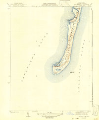
1942 Map of Monomoy Point
USGS Topo · Published 1942About this map
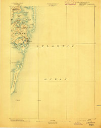
Monomoy Island stretches southward into the confluence of Nantucket Sound and the Atlantic Ocean, as documented in this 1940 survey. The landscape is defined by dynamic coastal features, including the sheltered waters of the Powder Hole near the southern tip and the curved reach of Hammonds Bend to the north. Human presence on this narrow spit is limited to specialized maritime and sporting outposts, notably the Coast Guard Sta near Monomoy Point and private enclaves such as the Monomoy Brant Club and Bristol Club. The presence of the Stone Horse Light Ship offshore highlights the island's role as a critical, yet hazardous, navigational landmark for vessels skirting the Cape. The map detail reveals a complex network of internal waterways like the Salt Drain and Rampy Hole, illustrating the island's permeable, ever-shifting nature before later natural breaches transformed the coastline.
Find a feature on this map
14 named features on this map. Tap any name to fly to it.
Don’t see what you’re looking for? This feature index may not catch every label — zoom into the map to look around manually.
Map Details
Editions of this 1942 Monomoy Point Map
2 editions found

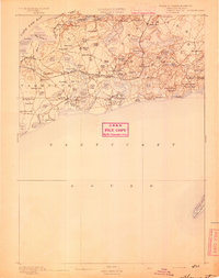
Other maps of this area

1887 · Yarmouth
USGS Topo · 1:62,500

1888 · Chatham
USGS Topo · 1:62,500

1889 · Yarmouth
USGS Topo · 1:62,500
1893 · Chatham
USGS Topo · 1:62,500
1893 · Yarmouth
USGS Topo · 1:62,500

1917 · Chatham
USGS Topo · 1:62,500

1942 · Cape Cod Bay
USGS Topo · 1:125,000

1942 · Chatham
USGS Topo · 1:31,680

1942 · Nauset
USGS Topo · 1:125,000

1942 · Nantucket
USGS Topo · 1:125,000