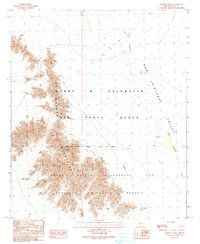
1990 Map of Monreal Well
USGS Topo · Published 1990About this map
The Mohawk Mountains rise sharply out of the desert floor in this 1990 provisional study, serving as a stark dividing line between the low-lying San Cristobal Valley and the surrounding arid plains. This section of Yuma County is defined by its vast federal tracts, where the Barry M Goldwater Air Force Range meets the Cabeza Prieta National Wildlife Refuge. Traces of early human activity and resource extraction are scattered along the western mountain slopes, evidenced by a Mine Shaft, an Adit, and a lone Prospect. In the valley, the Monreal Well (Dry) and a nearby Corral suggest a history of seasonal grazing or failed water-seeking in an environment primarily dominated by the seasonal San Cristobal Wash. The presence of a Ruin tucked into the mountain foothills further underscores the transient nature of settlement in this part of the Sonoran Desert.
Find a feature on this map
17 named features on this map. Tap any name to fly to it.
Don’t see what you’re looking for? This feature index may not catch every label — zoom into the map to look around manually.
Map Details
Editions of this 1990 Monreal Well Map
This is the sole edition of this map. No revisions or reprints were ever made.
Other maps of this area

1927 · Aguila Mountains
USGS Topo · 1:48,000

1927 · Kim
USGS Topo · 1:62,500

1930 · Aguila Mountains
USGS Topo · 1:62,500

1931 · Kim
USGS Topo · 1:62,500

1953 · Ajo
USGS Topo · 1:250,000

1957 · Ajo
USGS Topo · 1:250,000

1958 · Ajo
USGS Topo · 1:250,000

1962 · Ajo
USGS Topo · 1:250,000

1963 · Ajo
USGS Topo · 1:250,000
1965 · Aguila Mountains
USGS Topo · 1:62,500