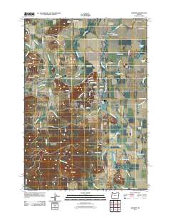
2011 Map of Monroe
USGS Topo · Published 2011About this map
The Long Tom River meanders through the eastern portion of this landscape, fed by a complex system of sloughs and lakes including Harkens Lake, Garlinghouse Lake, and Goodman Lake. In the early 21st century, the agricultural and residential patterns of this Benton County region are anchored by the town of Monroe, where the Monroe Post Office serves as a central hub. The western terrain rises toward the heights of Win Ridge, providing a contrast to the flat river bottomlands where Muddy Creek and Shafer Creek drain the surrounding fields.
Find a feature on this map
109 named features on this map. Tap any name to fly to it.
Don’t see what you’re looking for? This feature index may not catch every label — zoom into the map to look around manually.
Map Details
Editions of this 2011 Monroe Map
This is the sole edition of this map. No revisions or reprints were ever made.
Other maps of this area

1909 · Harrisburg
USGS Topo · 1:31,680

1909 · Elmira
USGS Topo · 1:62,500

1910 · Eugene
USGS Topo · 1:62,500

1911 · Monroe
USGS Topo · 1:31,680

1911 · Inavale
USGS Topo · 1:31,680

1912 · Halsey
USGS Topo · 1:62,500

1922 · Monroe
USGS Topo · 1:62,500

1922 · Elmira
USGS Topo · 1:62,500

1939 · Monroe
USGS Topo · 1:62,500

1940 · Eugene
USGS Topo · 1:62,500