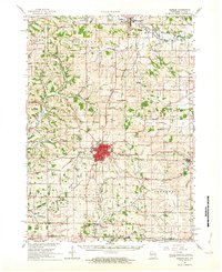
1962 Map of Monroe
USGS Topo · Published 1964About this map
Monroe stands as the primary hub of Green County on this mid-century survey, its street grid surrounded by a landscape of productive dairy farms and rural crossroads. The city is a convergence point for the Illinois Central and the Chicago Milwaukee St Paul and Pacific railroads, which facilitated the region's agricultural economy. This 1960s snapshot shows the city before major highway expansion, featuring local infrastructure like the Fairgrounds, the Monroe Municipal Airport, and the Radio Tower (WEKZ).
Find a feature on this map
80 named features on this map. Tap any name to fly to it.
Don’t see what you’re looking for? This feature index may not catch every label — zoom into the map to look around manually.
Map Details
Editions of this 1962 Monroe Map
2 editions found
Other maps of this area

1889 · Evansville
USGS Topo · 1:62,500

1893 · Brodhead
USGS Topo · 1:62,500

1894 · Evansville
USGS Topo · 1:62,500

1906 · Evansville
USGS Topo · 1:62,500

1920 · Monroe
USGS Topo · 1:62,500

1922 · Monroe
USGS Topo · 1:62,500

1923 · Blanchardville
USGS Topo · 1:62,500

1923 · New Glarus
USGS Topo · 1:62,500

1923 · South Wayne
USGS Topo · 1:62,500

1932 · Pecatonica
USGS Topo · 1:62,500