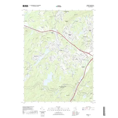
2019 Map of Monroe
USGS Topo · Published 2019About this map
The village of Monroe serves as a central hub in this Southern Orange County landscape, where the dense suburban development of Kiryas Joel and the commercial corridors of Harriman meet the protected expanses of Harriman State Park. The map documents a complex water system, from the sprawling Mombasha Lake to smaller reservoirs like Earl Reservoir and Hillside Lake, reflecting the region's long history of managing water resources for local industry and residential growth.
Find a feature on this map
72 named features on this map. Tap any name to fly to it.
Don’t see what you’re looking for? This feature index may not catch every label — zoom into the map to look around manually.
Map Details
Editions of this 2019 Monroe Map
This is the sole edition of this map. No revisions or reprints were ever made.
Other maps of this area

1891 · Greenwood Lake
USGS Topo · 1:62,500

1891 · Ramapo
USGS Topo · 1:62,500

1893 · Greenwood Lake
USGS Topo · 1:62,500

1893 · Ramapo
USGS Topo · 1:62,500

1902 · Schunemunk
USGS Topo · 1:62,500

1903 · Greenwood Lake
USGS Topo · 1:62,500

1906 · Goshen
USGS Topo · 1:62,500

1908 · Goshen
USGS Topo · 1:62,500

1910 · Ramapo
USGS Topo · 1:62,500

1910 · Greenwood Lake
USGS Topo · 1:62,500