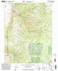
2001 Map of Monroe Peak
USGS Topo · Published 2003About this map
Monroe Peak serves as a dominant topographic anchor in this high-altitude landscape of central Utah. Established within the Fishlake National Forest, the terrain is defined by a complex network of canyons and meadows, where water management is central to the area's utility. The presence of the South Bend Canal and the Power Plant near Monroe indicates early 20th-century infrastructure developed to harness the steep descent of Monroe Creek. High-elevation plateaus like Manning Meadows and Monroe Meadows provided critical grazing land, while smaller water bodies such as Lower Hunts Lake and several reservoirs, including Scrub Flat Reservoir, were vital for sustaining the seasonal use of these lands. The map also records recreational developments such as the Monrovian Park Campground and distinctive geographic landmarks like Devils Dutch Oven and Fitzgerald Park.
Find a feature on this map
63 named features on this map. Tap any name to fly to it.
Don’t see what you’re looking for? This feature index may not catch every label — zoom into the map to look around manually.
Map Details
Editions of this 2001 Monroe Peak Map
This is the sole edition of this map. No revisions or reprints were ever made.
Other maps of this area

1885 · Beaver
USGS Topo · 1:250,000

1885 · Fish Lake
USGS Topo · 1:250,000

1896 · Fish Lake
USGS Topo · 1:250,000

1940 · Monroe
USGS Topo · 1:62,500

1944 · Monroe
USGS Topo · 1:62,500

1945 · Marysvale
USGS Topo · 1:62,500

1947 · Marysvale
USGS Topo · 1:62,500

1953 · Richfield
USGS Topo · 1:250,000

1956 · Salina
USGS Topo · 1:250,000

1958 · Richfield
USGS Topo · 1:250,000