Loading...
Loading map...1940 Map of Monroe
USGS Topo · Published 1967About this map
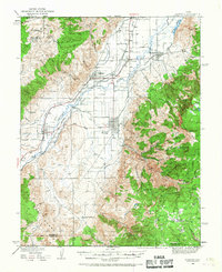
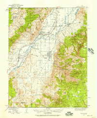
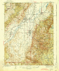
The Sevier River valley serves as the central artery for this agricultural corridor, where a complex network of canals supports a string of early Utah settlements. The map highlights the intensive irrigation required for the valley floor, specifically around Monroe and Elsinore, while the higher elevations are dominated by the Fishlake National Forest. Evidence of early 20th-century transportation is prominent, with the Denver and Rio Grande Western railroad paralleling the river and connecting small hubs like Joseph and Nibley.
Find a feature on this map
54 named features on this map. Tap any name to fly to it.
Don’t see what you’re looking for? This feature index may not catch every label — zoom into the map to look around manually.
Map Details
Date Portrayed1940
Date Published1967
PublisherU.S. Geological Survey
Map TypeTopographic
Scale1:62,500
Physical Dimensions17 x 20.7 inches
Editions of this 1940 Monroe Map
2 editions found
Historical Maps of Richfield Through Time
Featured Locations
Source Details
SourceU.S. Geological Survey
CopyrightPublic Domain