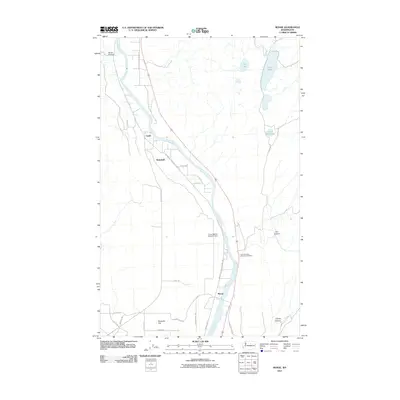
2011 Map of Monse
USGS Topo · Published 2011About this map
The Okanogan River carves a central path through this portion of Okanogan County, dictating the placement of infrastructure and small communities in the early 21st century. The settlement of Monse sits along the river's eastern bank, while further upstream, the small locales of Ophir and Wakefield mark the historical corridor of the Old Highway 97. This landscape is defined by the sharp contrast between the irrigated agricultural activity at Brewster Flat and the arid, coulee-like terrain punctuated by Soap Lake and BJ Lake to the northeast. Cultural markers, such as the Fort Okanogan Memorial Cemetery, provide vital links to the area's heritage near the Crazy Rapids Reservoir Dam. The map details an extensive network of rural routes, including Wakefield Cameron Lake Rd and Monse Bridge Rd, which connect the canyon-scored uplands of Davis Canyon and Dan Canyon to the valley floor.
Find a feature on this map
29 named features on this map. Tap any name to fly to it.
Don’t see what you’re looking for? This feature index may not catch every label — zoom into the map to look around manually.
Map Details
Editions of this 2011 Monse Map
This is the sole edition of this map. No revisions or reprints were ever made.
Other maps of this area

1905 · Okanogan
USGS Topo · 1:125,000

1954 · Okanogan
USGS Topo · 1:250,000

1956 · Loup Loup
USGS Topo · 1:62,500

1957 · Okanogan
USGS Topo · 1:62,500

1957 · Bridgeport
USGS Topo · 1:62,500

1957 · Brewster
USGS Topo · 1:62,500

1958 · Okanogan
USGS Topo · 1:250,000

1980 · Okanogan
USGS Topo · 1:24,000
1980 · Bridgeport Point
USGS Topo · 1:24,000
1980 · Bridgeport
USGS Topo · 1:24,000