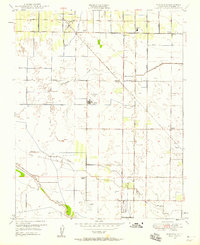
1949 Map of Monson
USGS Topo · Published 1958About this map
Agricultural development across the Central Valley is defined by an intricate network of irrigation canals on this 1949 survey. The landscape is a grid of orchards and fields partitioned by the Button Ditch, Banks Ditch, and Elkhorn Ditch, reflecting the intensive water management of the Tulare Lake Basin. Two major rail lines, the Southern Pacific and the Atchison Topeka And Santa Fe, converge near Monson, providing essential transit for local harvests. Notable civic sites include the Sequoia Home and several local schools like the Chatham School and Taurusa School. In the southern portion of the map, the St Johns River and Elbow Creek wind through the valley floor, where the Piepgrass Airport and the Sequoia Field airport suggest the growing importance of aviation to this rural Tulare County community.
Find a feature on this map
25 named features on this map. Tap any name to fly to it.
Don’t see what you’re looking for? This feature index may not catch every label — zoom into the map to look around manually.
Map Details
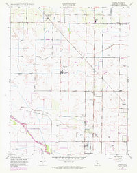
Editions of this 1949 Monson Map
2 editions found
Other maps of this area

1921 · Stokes Mountain
USGS Topo · 1:24,000

1922 · Trimmer
USGS Topo · 1:96,000

1923 · Sultana
USGS Topo · 1:31,680

1924 · Reedley
USGS Topo · 1:31,680

1924 · Dinuba
USGS Topo · 1:125,000

1924 · Stokes Mountain
USGS Topo · 1:31,680

1926 · Goshen
USGS Topo · 1:31,680

1926 · Ivanhoe
USGS Topo · 1:31,680

1926 · Exeter
USGS Topo · 1:31,680

1927 · Traver
USGS Topo · 1:31,680