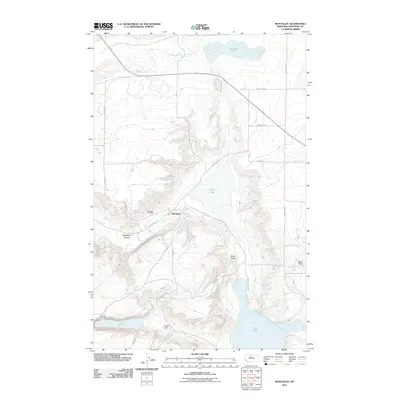
2011 Map of Montague
USGS Topo · Published 2011About this map
The small settlement of Montague sits at the heart of this Chouteau County landscape, defined by a network of drainage coulees and seasonal basins. Local history is anchored at the Montague Cemetery, situated just west of the town center near the intersection of several local routes. The area's water management is evident in the presence of Kheta Dam, which regulates the flow in an environment marked by prominent depressions such as White Lake, Harwood Lake, and Big Lake. The terrain is further characterized by distinct natural features like Telephone Coulee and Windy Coulee, while the naming of Railroad Ave suggests the enduring footprint of former transportation corridors that once shaped this plains community. Notable landmarks like Black Rock provide further points of orientation across the open country.
Find a feature on this map
19 named features on this map. Tap any name to fly to it.
Don’t see what you’re looking for? This feature index may not catch every label — zoom into the map to look around manually.
Map Details
Editions of this 2011 Montague Map
This is the sole edition of this map. No revisions or reprints were ever made.
Other maps of this area

1890 · Fort Benton
USGS Topo · 1:250,000

1892 · Fort Benton
USGS Topo · 1:250,000

1897 · Fort Benton
USGS Topo · 1:250,000

1953 · Rocky Lake
USGS Topo · 1:24,000

1953 · O'Hanlon Coulee
USGS Topo · 1:24,000

1954 · Great Falls
USGS Topo · 1:250,000

1957 · Great Falls
USGS Topo · 1:250,000
1972 · Stranahan SE
USGS Topo · 1:24,000
1972 · Montague
USGS Topo · 1:24,000
1972 · Shonkin
USGS Topo · 1:24,000