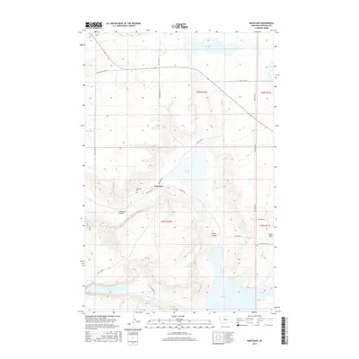
2017 Map of Montague
USGS Topo · Published 2017About this map
Montague serves as the focal point for this section of Chouteau County, where the high plains of north-central Montana are carved by dramatic drainages. The landscape is defined by its water and topography, featuring a series of intermittent lakes including White Lake, Lost Lake, and Big Lake. These basins sit alongside deep erosion features such as Telephone Coulee and Windy Coulee, which cut through the surrounding tablelands. Local history and genealogy interests are centered on the Montague Cem and the small grid of the settlement itself. The region's agricultural infrastructure is evident through a network of rural routes like Frenchman Ridge Rd and the presence of Railroad Ave, reflecting the vital role of transit in this isolated ranching and farming territory. To the east, the terrain rises toward the feature known as Black Rock, overlooking the expansive Coulee system.
Find a feature on this map
27 named features on this map. Tap any name to fly to it.
Don’t see what you’re looking for? This feature index may not catch every label — zoom into the map to look around manually.
Map Details
Editions of this 2017 Montague Map
This is the sole edition of this map. No revisions or reprints were ever made.
Other maps of this area

1890 · Fort Benton
USGS Topo · 1:250,000

1892 · Fort Benton
USGS Topo · 1:250,000

1897 · Fort Benton
USGS Topo · 1:250,000

1953 · Rocky Lake
USGS Topo · 1:24,000

1953 · O'Hanlon Coulee
USGS Topo · 1:24,000

1954 · Great Falls
USGS Topo · 1:250,000

1957 · Great Falls
USGS Topo · 1:250,000
1972 · Stranahan SE
USGS Topo · 1:24,000
1972 · Montague
USGS Topo · 1:24,000
1972 · Shonkin
USGS Topo · 1:24,000