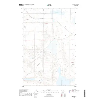
2020 Map of Montague
USGS Topo · Published 2020About this map
Montague serves as the focal point of this high plains landscape in Chouteau County, where the grid of county roads meets the natural drainage patterns of the Missouri River watershed. The settlement is anchored by Railroad Ave and the nearby Montague Cem, reflecting a community structure built around early transportation and local heritage. The terrain is defined by a series of depressions and coulees, including Telephone Coulee and Windy Coulee, which channel seasonal runoff toward significant water bodies like Big Lake and Lost Lake. These alkaline basins and the prominent Black Rock formation highlight a geography shaped by glacial activity and wind erosion. The road network, including Frenchman Ridge Rd and Jensen Coulee Rd, follows the section lines of the Public Land Survey System, illustrating the enduring influence of the 19th-century land disposal acts on the modern Montana landscape.
Find a feature on this map
27 named features on this map. Tap any name to fly to it.
Don’t see what you’re looking for? This feature index may not catch every label — zoom into the map to look around manually.
Map Details
Editions of this 2020 Montague Map
This is the sole edition of this map. No revisions or reprints were ever made.
Other maps of this area

1890 · Fort Benton
USGS Topo · 1:250,000

1892 · Fort Benton
USGS Topo · 1:250,000

1897 · Fort Benton
USGS Topo · 1:250,000

1953 · Rocky Lake
USGS Topo · 1:24,000

1953 · O'Hanlon Coulee
USGS Topo · 1:24,000

1954 · Great Falls
USGS Topo · 1:250,000

1957 · Great Falls
USGS Topo · 1:250,000
1972 · Stranahan SE
USGS Topo · 1:24,000
1972 · Montague
USGS Topo · 1:24,000
1972 · Shonkin
USGS Topo · 1:24,000