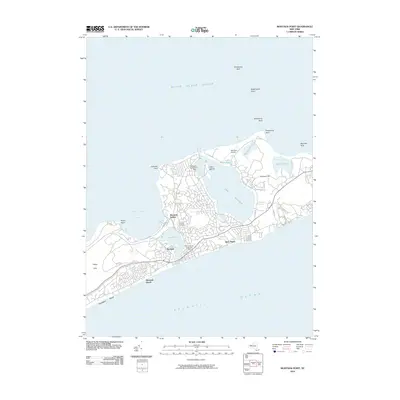
2010 Map of Montauk Point
USGS Topo · Published 2010About this map
Lake Montauk serves as the central geographic anchor for this tip of Long Island, surrounded by a complex network of coastal ponds and bays. The landscape is defined by the transition from the protected waters of Fort Pond Bay and Fort Pond to the open expanse of the Atlantic Ocean and Block Island Sound. Transportation infrastructure is prominently featured, including the Montauk Station rail terminus and aviation facilities like Montauk Airport and the Montauk Seaplane Base on Star Island. Significant local history and community markers are present, such as the Fort Hill Cemetery and the Perry B Duryea Junior Post Office. The map captures a well-developed coastal area with established residential zones like Ditch Plains and Montauk Beach alongside preserved terrain including Prospect Hill and the heights of Hither Hills.
Find a feature on this map
34 named features on this map. Tap any name to fly to it.
Don’t see what you’re looking for? This feature index may not catch every label — zoom into the map to look around manually.
Map Details
Editions of this 2010 Montauk Point Map
This is the sole edition of this map. No revisions or reprints were ever made.
Other maps of this area

1903 · Gardiners Island
USGS Topo · 1:62,500

1904 · Easthampton
USGS Topo · 1:62,500

1904 · Gardiners Island
USGS Topo · 1:62,500

1904 · Montauk
USGS Topo · 1:62,500

1921 · Gardiners Island
USGS Topo · 1:62,500

1921 · Easthampton
USGS Topo · 1:62,500
1942 · Montauk Point
USGS Topo · 1:24,000

1942 · Block Island
USGS Topo · 1:125,000

1943 · Gardiners Island East
USGS Topo · 1:24,000
1947 · Napeague Beach
USGS Topo · 1:24,000
Featured Places
- East Hampton, NY
- Montauk, East Hampton
- Montauk Beach, Montauk
- Ditch Plains, Montauk
- Montauk Station, Montauk