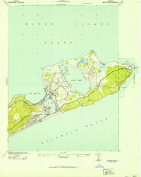
1942 Map of Montauk Point
USGS Topo · Published 1942About this map
Montauk sits at the eastern tip of Long Island, serving as a critical coastal outpost during the early 1940s. This survey, prepared by the Corps of Engineers, U.S. Army, documents the strategic landscape of the point, where the Long Island railroad terminates near Fort Pond. The map reveals a shore-oriented infrastructure including the Ditch Plain LSS and Hither Plain LSS life-saving stations, essential for navigating the waters between Block Island Sound and the Atlantic Ocean.
Find a feature on this map
23 named features on this map. Tap any name to fly to it.
Don’t see what you’re looking for? This feature index may not catch every label — zoom into the map to look around manually.
Map Details
Editions of this 1942 Montauk Point Map
This is the sole edition of this map. No revisions or reprints were ever made.
Other maps of this area

1903 · Gardiners Island
USGS Topo · 1:62,500

1904 · Easthampton
USGS Topo · 1:62,500

1904 · Gardiners Island
USGS Topo · 1:62,500

1904 · Montauk
USGS Topo · 1:62,500

1921 · Gardiners Island
USGS Topo · 1:62,500

1921 · Easthampton
USGS Topo · 1:62,500

1942 · Block Island
USGS Topo · 1:125,000

1943 · Gardiners Island East
USGS Topo · 1:24,000
1947 · Napeague Beach
USGS Topo · 1:24,000

1947 · Providence
USGS Topo · 1:250,000
Featured Places
- East Hampton, NY
- Montauk, East Hampton
- Montauk Beach, Montauk
- Ditch Plains, Montauk
- Montauk Station, Montauk