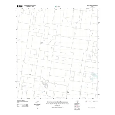
2010 Map of Monte Christo
USGS Topo · Published 2010About this map
The agricultural and industrial character of Hidalgo County is visible in this study of the Rio Grande Valley landscape. The settlement at Monte Christo and the nearby Moore Field anchor the southern portion of the quadrangle, while the presence of the Monte Christo Gas Field points to the region's energy resources. The map documents a structured grid of rural roads and land divisions, where water remains a critical concern, evidenced by named landmarks like the El Golfo Windmill and La Trenca Windmill. North of the La Gloria Ranch, the terrain is defined by a network of farm-to-market roads, including Fm 681 and Fm 490, which connect these isolated ranching and resource-extraction sites to the larger valley economy.
Find a feature on this map
14 named features on this map. Tap any name to fly to it.
Don’t see what you’re looking for? This feature index may not catch every label — zoom into the map to look around manually.
Map Details
Editions of this 2010 Monte Christo Map
This is the sole edition of this map. No revisions or reprints were ever made.
Other maps of this area

1939 · Linn
USGS Topo · 1:62,500

1939 · La Reforma
USGS Topo · 1:62,500

1940 · Monte Christo
USGS Topo · 1:62,500

1949 · Mc Allen
USGS Topo · 1:250,000

1954 · McAllen
USGS Topo · 1:250,000

1957 · Mc Allen
USGS Topo · 1:250,000

1962 · McAllen
USGS Topo · 1:250,000

1963 · Monte Christo
USGS Topo · 1:24,000

1963 · Edinburg
USGS Topo · 1:24,000
1963 · Faysvillle
USGS Topo · 1:24,000