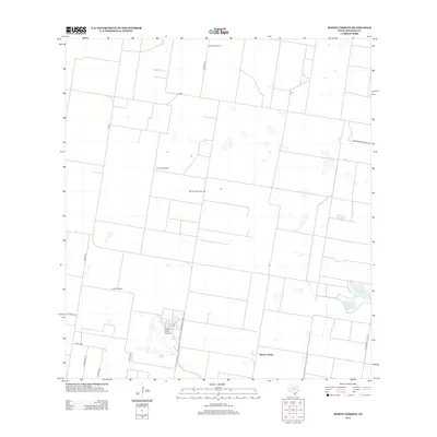
2012 Map of Monte Christo
USGS Topo · Published 2012About this map
Monte Christo Gas Field sits at the heart of this Hidalgo County landscape, where the traditional ranching heritage of South Texas meets modern industrial extraction. The area is defined by a rigid grid of agricultural and access roads, including 12 Mile Line and 11 Mile Line, which carve the terrain into large parcels. Aviation and resource management are prominent, with the Moore Field Airport providing a significant logistical hub in the southern portion of the quadrangle. Smaller-scale landmarks like the El Golfo Windmill and La Trenca Windmill underscore the continued importance of water management in this semi-arid region. Established holdings such as La Gloria Ranch persist among the intersecting routes of FM-490 and Brushline Rd, illustrating the transition from open range to a more developed rural infrastructure.
Find a feature on this map
16 named features on this map. Tap any name to fly to it.
Don’t see what you’re looking for? This feature index may not catch every label — zoom into the map to look around manually.
Map Details
Editions of this 2012 Monte Christo Map
This is the sole edition of this map. No revisions or reprints were ever made.
Other maps of this area

1939 · Linn
USGS Topo · 1:62,500

1939 · La Reforma
USGS Topo · 1:62,500

1940 · Monte Christo
USGS Topo · 1:62,500

1949 · Mc Allen
USGS Topo · 1:250,000

1954 · McAllen
USGS Topo · 1:250,000

1957 · Mc Allen
USGS Topo · 1:250,000

1962 · McAllen
USGS Topo · 1:250,000

1963 · Monte Christo
USGS Topo · 1:24,000

1963 · Edinburg
USGS Topo · 1:24,000
1963 · Faysvillle
USGS Topo · 1:24,000