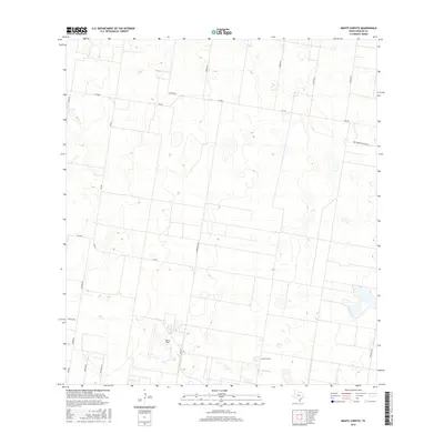
2016 Map of Monte Christo
USGS Topo · Published 2016About this map
Monte Christo anchors this portion of Hidalgo County, representing a landscape defined by expansive rural tracts and a geometric grid of farm roads. The area surrounding Moore Field exhibits the characteristic South Texas pattern of large-scale agricultural development and resource management, with terrain punctuated by numerous small depressions and drainage basins. A dense network of local thoroughfares, including Fm 681 and Fm 490, facilitates movement across the flat coastal plain. The naming conventions of the secondary roads, such as Kutzer Rd, Kamien Rd, and Macnormans Grove Rd, offer a glimpse into the local landownership and family histories that have shaped this region's development since the early twentieth century. This survey provides a clear view of the transition between cultivated fields and the scrubland typical of the Rio Grande Valley hinterlands.
Find a feature on this map
20 named features on this map. Tap any name to fly to it.
Don’t see what you’re looking for? This feature index may not catch every label — zoom into the map to look around manually.
Map Details
Editions of this 2016 Monte Christo Map
This is the sole edition of this map. No revisions or reprints were ever made.
Other maps of this area

1939 · Linn
USGS Topo · 1:62,500

1939 · La Reforma
USGS Topo · 1:62,500

1940 · Monte Christo
USGS Topo · 1:62,500

1949 · Mc Allen
USGS Topo · 1:250,000

1954 · McAllen
USGS Topo · 1:250,000

1957 · Mc Allen
USGS Topo · 1:250,000

1962 · McAllen
USGS Topo · 1:250,000

1963 · Monte Christo
USGS Topo · 1:24,000

1963 · Edinburg
USGS Topo · 1:24,000
1963 · Faysvillle
USGS Topo · 1:24,000