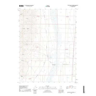
2018 Map of Monte Neva Hot Springs
USGS Topo · Published 2018About this map
Monte Neva Hot Springs serves as the focal point of this arid Steptoe Valley landscape, where geothermal activity defines the local geography. To the south, the settlement of Warm Springs lies along the transition between the valley floor and the foothills. The eastern edge of the Egan Range dominates the western portion of the map, deeply incised by a series of drainages including Pluto Canyon, Rattlesnake Canyon, and Log Canyon. These canyons channel seasonal runoff toward the marshy expanse of Duck Creek, which meanders northward through the valley. The presence of Old Hwy 93 and several county roads, such as White Pine Co Road 27, indicates a landscape long navigated for its water resources and transit routes. Small perennial points like Cold Spring and named drainages like Mattier Creek provide critical points of interest for understanding the historical hydrology of this White Pine County corridor.
Find a feature on this map
26 named features on this map. Tap any name to fly to it.
Don’t see what you’re looking for? This feature index may not catch every label — zoom into the map to look around manually.
Map Details
Editions of this 2018 Monte Neva Hot Springs Map
This is the sole edition of this map. No revisions or reprints were ever made.
Other maps of this area

1956 · Ely
USGS Topo · 1:250,000

1959 · Ely
USGS Topo · 1:250,000

1963 · Ely
USGS Topo · 1:250,000

1982 · Borchert Spring
USGS Topo · 1:24,000
1982 · Monte Neva Hot Springs
USGS Topo · 1:24,000
1982 · Steptoe Ranch
USGS Topo · 1:24,000
1982 · Steptoe
USGS Topo · 1:24,000
1982 · Schellbourne
USGS Topo · 1:24,000
1982 · Telegraph Peak
USGS Topo · 1:24,000
1982 · Mattier Creek
USGS Topo · 1:24,000