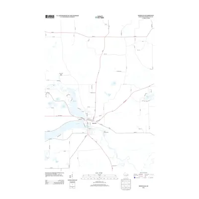
2013 Map of Montello
USGS Topo · Published 2013About this map
The Fox River and Montello River converge at the settlement of Montello, creating a complex aquatic geography defined by Lake Montello and the eastern reach of Buffalo Lake. This 2013 survey illustrates a landscape where water and transportation are inextricably linked, with State Road 23 and Wi-22 serving as the primary corridors through the lake-dotted terrain. Small aviation facilities like the Snow Crest Ranch Airport and Krist Island Airport sit among the glacial depressions that form numerous named water bodies, including Moon Lake, Echo Lake, and Spring Lake. The street grid of the town center transitions into a network of county highways, such as Co HWY-C and Co HWY-J, which provide access to the rural residential clusters and recreation-focused properties surrounding the larger lakes.
Find a feature on this map
76 named features on this map. Tap any name to fly to it.
Don’t see what you’re looking for? This feature index may not catch every label — zoom into the map to look around manually.
Map Details
Editions of this 2013 Montello Map
This is the sole edition of this map. No revisions or reprints were ever made.
Other maps of this area

1902 · Portage
USGS Topo · 1:62,500

1915 · Neshkoro
USGS Topo · 1:48,000

1918 · Neshkoro
USGS Topo · 1:62,500

1955 · Randolph
USGS Topo · 1:62,500

1957 · Madison
USGS Topo · 1:250,000

1960 · Madison
USGS Topo · 1:250,000

1961 · Montello
USGS Topo · 1:62,500

1962 · Portage
USGS Topo · 1:62,500

1963 · Neshkoro
USGS Topo · 1:62,500
1980 · Marquette
USGS Topo · 1:24,000