
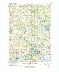
1961 Map of Montello
USGS Topo · Published 1963About this map
Buffalo Lake anchors the southern landscape of this central Wisconsin region, where the C & N W railroad tracks parallel the water through Packwaukee. The area is defined by a complex network of glacial kettle lakes and marshes, most notably the Germania Marsh Wildlife Area and its surrounding wetlands near Germania. Numerous small rural institutions dot the townships, from the Stone Ch and Imm Ch to the Haney Sch, reflecting a dense pattern of mid-century agricultural settlement.
Find a feature on this map
92 named features on this map. Tap any name to fly to it.
Don’t see what you’re looking for? This feature index may not catch every label — zoom into the map to look around manually.
Map Details
Editions of this 1961 Montello Map
2 editions found
Other maps of this area

1902 · Portage
USGS Topo · 1:62,500

1902 · Briggsville
USGS Topo · 1:62,500

1915 · Neshkoro
USGS Topo · 1:48,000

1918 · Neshkoro
USGS Topo · 1:62,500

1955 · Randolph
USGS Topo · 1:62,500

1955 · Green Bay
USGS Topo · 1:250,000

1957 · Madison
USGS Topo · 1:250,000

1958 · Briggsville
USGS Topo · 1:62,500

1958 · Coloma
USGS Topo · 1:48,000

1959 · Wautoma
USGS Topo · 1:48,000