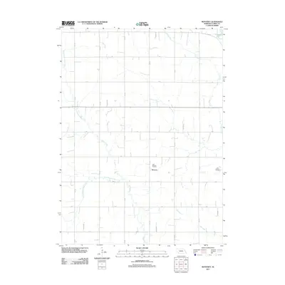
2011 Map of Monterey
USGS Topo · Published 2011About this map
Monterey serves as the focal point of this Cuming County landscape, a quiet settlement defined by the grid of rural roads and the winding paths of several waterways. The agricultural character of the region is punctuated by the presence of Saint Boniface Cemetery near the town site and Saint Anthony Cemetery further to the east, providing important markers for genealogical research in this part of Nebraska. The hydrology is dominated by the branches of Pebble Creek, including the North Branch Pebble Creek and South Branch Pebble Creek, which carve natural courses through the surveyed sections. In the northeast corner, McKirahan Lake and the drainage of Fisher Creek reflect the local topography. This early 21st-century survey documents the persistent rural structure of the area, where naming conventions like D Rd and River Rd define the movement of goods and people across the plains.
Find a feature on this map
26 named features on this map. Tap any name to fly to it.
Don’t see what you’re looking for? This feature index may not catch every label — zoom into the map to look around manually.
Map Details
Editions of this 2011 Monterey Map
This is the sole edition of this map. No revisions or reprints were ever made.
Other maps of this area

1955 · Fremont
USGS Topo · 1:250,000

1957 · Fremont
USGS Topo · 1:250,000

1958 · Fremont
USGS Topo · 1:250,000

1963 · Wisner
USGS Topo · 1:24,000

1966 · West Point NW
USGS Topo · 1:24,000

1966 · Monterey
USGS Topo · 1:24,000
1966 · Beemer
USGS Topo · 1:24,000

1966 · Snyder
USGS Topo · 1:24,000

1966 · Aloys
USGS Topo · 1:24,000

1966 · Scribner
USGS Topo · 1:24,000